Maps
An RV winds its way along a highway, surrounded by dense forest, tall mountains and a calm river.

The Great Wilderness: Northern BC Route 16

7-14 days, 1006 km (625.1 mi)

A soul-stirring odyssey that stretches from the Pacific Ocean to the Canadian Rockies across some of the grandest scenery in British Columbia.

Share  Facebook Twitter pinterest logoPinterest

Highway 16 lays claim to two of British Columbia’s biggest scene-stealers: the Pacific-backed Great Bear Rainforest and Mt. Robson, the highest peak in the Canadian Rockies. Few other drives in the country deliver nature on this scale. From the coastal vibes of Prince Rupert to the mountain-fringed town of Valemount, it links together mind-boggling landscapes, vibrant Indigenous cultures, impressive wildlife, friendly towns, and one epic playground for outdoor recreation. The Great Wilderness awaits.

Part 1

Prince Rupert to Terrace

Prince Rupert harbour | Marty Clemens

Prince Rupert’s laidback charm offers a leisurely start to your big adventure. Linger over fish and chips, pints of local beer, and moody coastal views before venturing beyond city limits to experience the sheer elemental force of its backyard: The Great Bear Rainforest. This famed wilderness area stretches from the tip of Northern Vancouver Island all the way to the Alaska border, encompassing marine refuges, old-growth forest, and abundance of flora and fauna. Experience its raw power firsthand on a local hike, floatplane tour, whale watching charter, or paddling trip.

Back in downtown Prince Rupert, a visit to the stunning, cedar-clad Museum of Northern BC grounds your excursion with important context—this region is home to the Ts’msyen Nation who, for millennia, have stewarded its lands and waters. Learn about their modern-day culture and admire the stunning works of Ts’msyen, Haida, and Nisga’a art on display.

Two people in kayaks haul up a net filled with crabs.

Crabbing by kayak with Skeena Kayaking | Northern BC Tourism/Kimberley Kufaas

Heading east, the first 100 kilometres (62 miles) of Highway 16 waste no time when it comes to jaw-dropping scenery. Hugging the contours of the Skeena River, your journey towards Terrace unfolds alongside thundering waterfalls, craning trees, and riverbanks of sedge and eelgrass. Indigenous communities like Kitselas and Skeena First Nations have depended upon the Skeena River Watershed for fishing, transportation, and trade routes for millennia and they continue to manage and protect these waters.

Take your time and detour to recreation areas rarely visited like Exchamsiks River Provincial Park, with its accessible walking trails through a giant cedar forest, and Exstew Falls, its towering spray worth every bump of the gnarled logging road leading to it. While you’re in the area, be sure to visit the House of Sim-Oi-Ghets off Highway 16. This gift shop, owned and operaated by Kitsumkalum, a Galts’ap (community), offers traditional and contemporary art and crafts.

Part 2

Terrace to Smithers

Accessible trails at Exchamsiks River Provincial Park | Northern BC Tourism/Marty Clemens

Terrace is a gateway by plane into The Great Wilderness. To the northeast of town is the upper Skeena River, best explored on a jet boat tour where you can nimbly work your way into the many tributaries that feed this mighty river. To the northwest is the Nass Valley, home to the Nisga’a Nation, as well as a scarred volcanic landscape and a partially submerged forest—two stops along a self-guided auto route tour that takes you past ancient lakes, turquoise rivers, and the soaring glass-encased Hli Goothl Wilp-Adokshl Nisg̱a’a (Nisga’a Museum), where one can learn from Indigenous storytellers and through an extensive collection of culturally significant artifacts. South of Terrace lies Kitimat. Here, a 90-kilometre-long fjord cleaves through the Coast Mountain Range, offering both high alpine adventures and deepwater fun. Don’t miss the area’s hot spring-studded shores; book a boat tour to experience their soothing waters and oceanside views.

A Gingolx person observes smoking salmon in a Nisga'a Nation smoke house.

Smoke house in village of Gingolx in the Nisga’a Nation | Grant Harder

In Terrace, options for adventure abound. Ringed by mountains, the area is primed for mountain biking, hiking, and rock climbing, though it’s the fly-fishing that lures many adventurers to these parts. The Skeena River is one of the world’s great fly-fishing rivers, home to all six species of salmon, and feisty steelhead trout. Head out on a charter and experience the thrill of angling in one of the world’s most lauded fishing destinations.

Down the road is the Kitselas Canyon National Historic Site, an important place to the Gitselasu people of the Ts’msyen Nation for more than 6,000 years, and once the only settlement along this section of the Skeena. Wander an interpretive trail to see four First Nations longhouses, plus clan poles and a spectacular viewpoint overlooking the rushing waters below.

An aerial view of the lush valley surrounded by mountains, with a jet boat cruising up the river.

Northern BC Jet Boat Tours | Calum Snape

Continue east on Highway 16 towards the Hazeltons. Named for the hazel bushes that line the river-carved terraces along this stretch of road, the area’s rugged geography has long shaped centuries of life in these canyons. Stegyoden (a Ts’msyen name meaning  “painted goat”)—the pyramid-shaped peak that defines the mercurial Roche de Double Range—looms over every viewpoint, including Hagwilget Canyon Bridge, a one-lane steel suspension bridge that links two sides of a 6,000-foot-deep river canyon. On the other side of this exhilarating crossing is the riverside Ksan Historical Village and Museum where you can immerse yourself in 10,000 years of Gitxsan history.

As you travel east, the craggy coast range melts into the farmlands and glittering lakes of the Bulkley Valley with its signature peak, Hudson Bay Mountain, towering over the town of Smithers.

Part 3

Smithers to Burns Lake

Smithers on Route 16 | Jongsun Park

Hudson Bay Mountain is your basecamp for outdoor recreation in Smithers. The town’s Alpen-themed main street sits directly at the foot of the mountain offering not only postcard views while you stroll, eat, or shop, but easy access to hiking, biking, or skiing. West of town, in Babine Mountain Provincial Park, you’ll find fields of wildflowers during the spring and summer months, subalpine meadows, and glacier-fed lakes. Don’t miss the popular overnight trek to Joe L’Orsa cabin, which lets you hunker down within arm’s reach of the striated peaks of Silver King Basin.

A person stands in front of a log cabin surrounded by rugged mountains and dense forest.

Babine Mountain Provincial Park | Northern BC Tourism/Shayd Johnson

At ground level, a chain of lakes—Kathlyn, Tyee, Chapman, and Seymour—provide a blueprint (and a taste of what’s to come) for the aquatic-inclined. Rent paddleboards, canoes, kayaks, and safety gear from Aquabatics in town before spending a tranquil afternoon following the curves of a lilypad-fringed shoreline.

About 45-minutes from Smithers sits the small community of Houston. This stretch of Highway 16 marks the first real indication of changing scenery as the edges of Smithers’ mountainous landscape widen, making room for a sweeping countryside laced with waterfalls and rivers.

A person with a backpack is perched on a tall mountain overlooking distant mountains and lush valley below.

China Knows peak in Houston | Northern BC Tourism/Abby Cooper

Get your bearings on a hike up China Knows, where the protruding chin of a granite rock juts precipitously into the sky and the scale of this region is most keenly felt. Down below, two famous fly-fishing rivers meet: the Bulkley and the Morice. If the world’s largest fly-rod—viewed as you enter town—is any hint, you’re in for a treat. Cast a line for trout from quiet riverbanks before checking out any number of waterfalls, big and small.

Farther east, the Lakes District is a freshwater lover’s dream, home to 3oo wilderness lakes, shoreline birds like the common loon, and other wildlife.

Part 4

Burns Lake to Prince George

From Burns Lake, take in this lake-dotted tapestry on a flightseeing tour with Lakes District Air. You’ll want to carve out time to tackle the Lakes District Circle Tour, a 97-kilometre-long loop via Highway 35 that links together four well-stocked fishing lakes, backcountry roads, and a free 20-minute ferry crossing. You’ll even spot North Tweedsmuir, part of one of the largest provincial parks in BC, in the distance.

A float plane flies above lakes that are surrounded by dense forest and snow-capped mountains.

Coles Lake and Piano Peak in the Tahtsa Range | Andrew Strain

Intersecting this watery landscape are dozens of adrenaline-inducing mountain bike trails. Boer Mountain is the epicenter of downhill hill action in the northwest, thanks to its growing trail network and location next to Kager Lake Recreation Site. Time your ride with the Big Pig Mountain Biking Festival, which attracts riders from across the province. Rent bikes and protective gear from Burnt Bikes in town before joining in on the fun.

An aerial view of two mountain bikers riding along a wooden bridge that spans across a lush valley.

Boer Mountain bike trails | Dave Silver

Heading east, Vanderhoof’s spacious horizon, generous lakefront, and relaxed pace are a much-needed pause along this jam-packed route. Spend a few days lounging at Paarens Beach and exploring local hiking trails and campgrounds. Be sure to stop in at Indigenous-owned G & F Market for a decadent slice of pizza (or two). On the shores of Stuart Lake you’ll find Fort St. James National Historic Site, a restored Hudson’s Bay Company post where you can discover the intertwined histories of early fur traders and the Dakelh people.

An museum guide stands in a fur trade era building, educating visitors about the heritage and history of the historic site.

Fort St. James National Historic Site | Northern BC Tourism/Andrew Strain

A short one-hour drive will land you on the steps of Prince George, the largest city in the region and one that embraces wilderness as much as it does culture.

Part 5

Prince George to Mt. Robson

Prince George’s lively downtown belies its access to nature. Its walkable core is made up of excellent restaurants, local shops, and interesting museums and art galleries. The traditional territory of the Lheidli T’enneh First Nation is crisscrossed with over 1,500 hectares of parks and green spaces, along with 106 kilometres (66 miles) of trails, dozens of lakes, and two rivers: the Nechako and the Fraser.

A short drive brings you to Ancient Forest/Chun T’oh Whudujut Park and Protected Area, one of the only inland temperate rainforests in the world. This incredible ecosystem houses thousand-year-old cedars and a rich diversity of flora. Admire towering trees on a short hike, then head to Sugarbowl-Grizzly Den Provincial Park, located 95 kilometres (59 miles) outside of the city—en route to Valemount—where multi-day backcountry adventures (and cabins) await. Before you depart Prince George, take a spin around the mountain bike trails of Pidherny Recreation Site then cool yourself along the shores of Purden Lake.

Two people in the distance walk along a rugged ridgeline that overlooks dense forest and orange-tinted mountains.

Sugarbowl-Grizzly Den Provincial Park | Northern BC Tourism/Andrew Strain

As you head east, the urban sprawl of Prince George gives way to the sweeping, broad-bottomed Robson Valley. This final stretch of Highway 16 is a gradual ascent through high country and woodland, and charming communities like McBride, until you reach your destination of Mt. Robson, the highest peak in the Canadian Rockies. The series of jagged mountains here span more than 1,600 kilometres (994 miles) across British Columbia and Alberta.

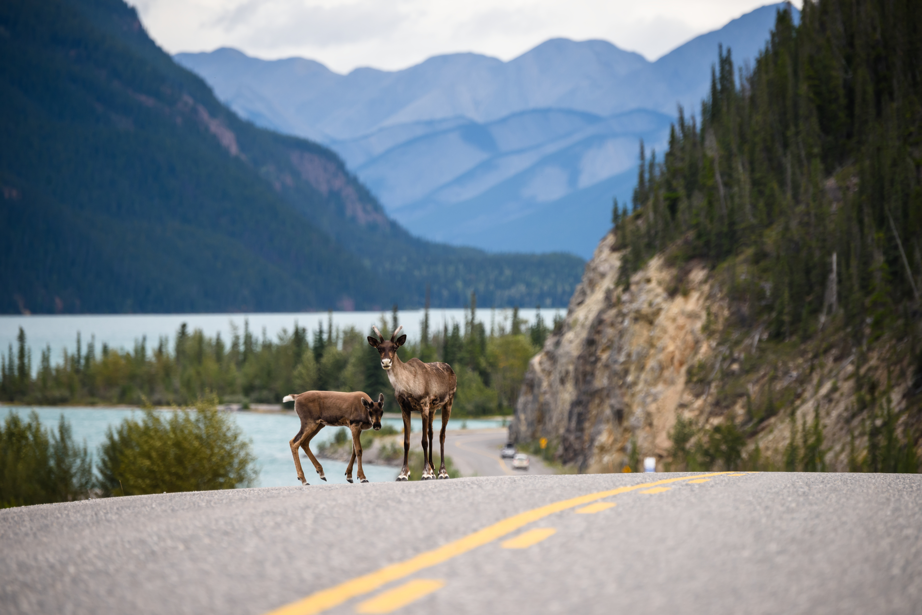
For road trippers, this is a great chance to spot wildlife—keep watch for moose, bears, mountain goats, and white-tailed deer as you drive. Regular pull-offs serve as trailheads and photo opportunities.

Take a detour along Highway 5 to Valemount. This friendly mountain town is home to a big and bold backyard, and that doesn’t just include the sentinel giant that stands within a 20-minute drive. Surrounded by three mountain ranges—the Rockies, Monashees, and Caribous—countless wilderness adventures await. Hike trails, fish clear streams, and raft down the rapids of the Fraser River, all in the shadow of Mt. Robson’s snow-capped peak. Mountain bikers will discover a labyrinth of exhilarating single- and doubletrack trails at the Valemount Bike Park. Expect fast and flowy turns and incredible vistas.

Back on Highway 16, the route’s big showstopper occurs at the entrance to the park, where you’ll get your first uninterrupted view of this granite monolith through the windshield.

A person looks in awe at the layered mountain flanks of Mt. Robson.

Mount Robson Provincial Park | Megan McLellan

You’ve now arrived at your final destination. A must-do is the signature Berg Lake Trail, which leads you in view of wildflower meadows, roaring waterfalls, a turquoise-hued glacier lake, and its iconic peak, though the park’s many other accessible trails are also worth your time. For a true bucket-list experience, arrange for a charter heli tour to see brag-worthy aerial angles. Due to a flood in 2021, parts of this trail may be closed temporarily for maintenance (be sure to check BC Parks for updates). The hike to Kinney Lake is an equally stunning alternative.

Pick a spot to overnight—whether that’s a vehicle-accessible campground or a backcountry wilderness site—and take your time exploring the wonders of this natural gem before capping off the road trip of a lifetime. The drive home is a chance to reflect on the monumental journey you’ve just experienced. Long after the scenery fades, the impression of this rugged landscape and its fascinating people is sure to remain—the ultimate road trip token.

A RV drives along a ribbon of highway that lies between farmland and rugged forest with mountains in the distance.

Highway 16 near McBride | Northern BC Tourism/Andrew Strain

Driving Directions

Part 1 - Vancouver
  • 6.25 km
  • 12 min
Show Map & Driving Directions

Plan Your Adventure Now

Need to Know

Find key travel information to plan your BC vacation.

Travel Info
Adventure Smart

Always check trail conditions before you head out, and no matter what outdoor activity you are planning, be prepared.

Plan Your Route
Plan Your Route

Check Drive BC for the latest information on road closures around the province.

Check Conditions
Travel Responsibly

Follow these tips to travel safely and responsibly in BC this season.

See the Tips
Places to Stay

Discover everything from luxury hotels and B&Bs to wilderness lodges and campsites.

Find Accommodation
Loading, please wait...
AI Chatbot is in-training and can make mistakes. Consider checking important information.
Terms and Conditions